
Jerusalem and the Temple of Solomon
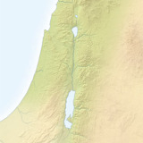
IT WAS called “the perfection of prettiness” and “the town of the grand King.” (Ps 48:2; 50:2; La 2:15) Jerusalem was the capital of God’s nation. (Ps 76:2) After David seized the city from the Jebusites and made it his capital, it was called “the City of David,” or just “Zion.”—2Sa 5:7.
While not enjoying a very strategic location, Jerusalem gained fame because God placed his name there. (De 26:2) It was the religious and administrative center of the nation.
Jerusalem is at an altitude of 2,500 feet (750 m) in the central mountains of Judea. The Bible refers to its “loftiness” and to worshipers as ‘going up’ to reach it. (Ps 48:2; 122:3, 4) The ancient city was surrounded by valleys: the Valley of Hinnom on the west and south and the torrent valley of Kidron on the east. (2Ki 23:10; Jer 31:40) The spring of Gihon a in the Kidron Valley and En-rogel to the south supplied fresh water, especially vital during enemy attacks.—2Sa 17:17.
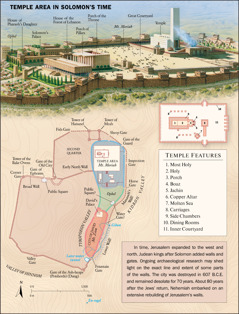
On the diagram on page 21, the City of David is in red. During the reigns of David and Solomon, the city extended northward to include Ophel (green) and Mount Moriah (blue). (2Sa 5:7-9; 24:16-25) Solomon built a magnificent temple to Jehovah on that higher spur. Imagine throngs of worshipers streaming up to “the mountain of Jehovah” for the annual festivals! (Zec 8:3) The road network represented on page 17 facilitated such travel.
Solomon’s temple, decorated with gold and precious stones, was one of the costliest buildings ever constructed. Significantly, Jehovah provided its architectural plan. As you see from the painting, the temple was flanked by large courtyards and administrative buildings. Its details are worthy of your study.—1Ki 6:1–7:51; 1Ch 28:11-19; Heb 9:23, 24.
[Footnote]
a King Hezekiah stopped up this spring and built a tunnel to a pool on the west side.—2Ch 32:4, 30.
[Diagram/Picture on page 21]
(For fully formatted text, see publication)
Jerusalem/Solomon’s Temple
TEMPLE AREA IN SOLOMON’S TIME
Temple Features
1. Most Holy
2. Holy
3. Porch
4. Boaz
5. Jachin
6. Copper Altar
7. Molten Sea
8. Carriages
9. Side Chambers
10. Dining Rooms
11. Inner Courtyard
TEMPLE AREA
Mt. Moriah
Dining Rooms
Carriages
Side Chambers
Most Holy
Boaz
Holy
Porch
Copper Altar
Jachin
Inner Courtyard
Carriages
Molten Sea
Ophel
Public Square?
Water Gate?
CITY OF DAVID
Mt. Zion
David’s Palace
Fountain Gate
Manasseh’s Wall?
Tower of Hananel
Tower of Meah
Sheep Gate
Gate of the Guard
Inspection Gate
Horse Gate
KIDRON VALLEY
Lower Wall?
Gihon
Later water tunnel
TYROPOEON VALLEY
Gate of the Ash-heaps (Potsherds) (Dung)
En-rogel
Valley Gate
VALLEY OF HINNOM
Corner Gate
Tower of the Bake Ovens
Broad Wall
Gate of Ephraim
Public Square
Gate of the Old City
Early North Wall
SECOND QUARTER
Fish Gate
[Picture]
Ophel
House of Pharaoh’s Daughter
Solomon’s Palace
House of the Forest of Lebanon
Porch of Pillars
Porch of the Throne
Mt. Moriah
Great Courtyard
Temple
[Picture on page 20]
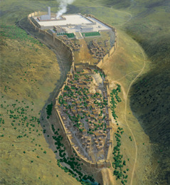
Foreground area is where “the City of David” was located. The temple was in the flat area (background)
[Picture on page 20]
Computer rendering of the ancient “City of David” and the temple of Solomon